
Donga Fm
Type Locality and Naming
Wells in the Termit Sub-Basin.
References: Lai et al., 2018; Lai et al., 2019; Ahmed et al., 2020; Alassane et al., 2020.
Synonym: Equivalent(s): This sub-surface formation correlates with the Zoo Baba Fm, Arentigué Fm, and Alanlara Fm, the Farak Fm, Béréré Fm and part of the Aschia-Tinamou Fm, the Ezerza Fm, Zoo-Baba Fm and lower part of the Agadem Fm, lower part of the Kafra Fm and lower part of the Séguédine Fm.
Lithology and Thickness
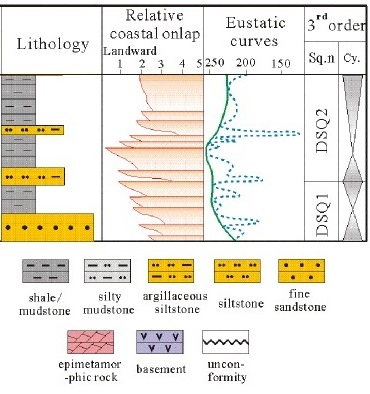
Two lithological units are present; the lower-interval (mudstone) and the middle to upper-interval (siltstone). Donga source rocks are mainly composed of clay (52.8%). These rocks also contain minerals such as muscovite (5.0%) and pyrite (12.8%). The clayey fractions (< 2 μm) are mainly dominated by kaolinite (51.0%). In addition, Donga clayey fractions are interstratified with two different sheets: illite-smectite (31.4%) and illite-chlorite (17.6%). The Donga Formation has two third-order sequences, namely, DSQ1 and DSQ2 from bottom to top (Fig. 1). Its thickness is 200 – 500 m in the Termit Sub-Basin and 200 to 1000 m in the Ténéré Sub-Basin.
[Figure 1: Generalized stratigraphic column and sequence division of the Donga Formation of the Termit Sub-Basin (Source: Lai et al., 2018)]
Relationships and Distribution
Lower contact
Underlying unit is the K1 Fm
Upper contact
Overlying unit is the Yogou Fm
Regional extent
East Niger Rift Basin - Termit and Ténéré Sub-Basins
GeoJSON
Fossils
Age
Depositional setting
Ranging from lacustrine to transitional and marine sources (Ahmed et al., 2020).
Additional Information
According to Haq et al. (1987), the eustatic curves and relative coastal onlap indicate that the Donga Fm and Yogou Fm correspond to the global Late Cretaceous sea-level highstand.